Zoar Valley Points of Interest Encyclopedia
(for details & pictures of each location click on the names listed)
Abyss Cascade: On the South Rim of the main branch Cattaraugus Creek.
American Bald Eagles - As Bald Eagles are in a comeback in North America it is no surprise they are now located in Zoar Valley.
Ancient White Pine Grove - In Erie County off Vail Rd
Awesome Plunge Cascade - On the South Rim of the main branch Cattaraugus Creek.
Bare Buns (or Butt) Falls - Is 140' high with a 6' wide crest. It falls in seven steps, only two lowest steps are viewable from the bottom as the upper seven hidden in the cliff side, the upper seven are viewable from the North Rim - but it is a difficult hike.
Basswood Terrace - One of the old growth terraces on the Main Branch Cattaraugus Creek. Named after the three huge Basswood trees located in this area. Also spots the home of an 119' Red Maple, 101' tall Yellow Birch, 114' Black Cherry and 136' Tulip tree.
Bear Point - In Deer Lick Nature Sanctuary at the end of the white trail.
Beaver Pond - coming soon
Big Falls - This 18' plunge falls off the MUA and on Private Property - No trespassing! Now part of WNYNSS's Rodger Sweetland Memorial Preserve.
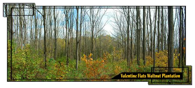
Black Walnut Plantation - In April 1968, a black walnut plantation was established in the Valentine Flats area. About
7,300 black walnut trees were planted on approximately 12 acres in the center of the Flats.
Blue Boat Beach - Located on the Main Branch of the Cattaraugus Creek, blue Boat Beach is the beach that has a blue aluminum boat on it. It is a the creek from the highest cliff in Zoar Valley - Giant Fluted Cliff at 415 feet high.
Bridal Veil Falls - see Ross Falls
Buff Cascade - 120' seasonal ribbon cascades on the South Branch Cattaraugus Creek.
Buttermilk Cascade - Also called Schoolmarms Falls and mistakenly Waterman's Cascade. Off the Zoar Valley MUA this 70' high cascade is on a tributary to Waterman Creek. All names fit as there is a rumor that in the 1920's a schoolmarm fell to her death there, the falls water churns up to look like buttermilk and the cascade feeds into Waterman creek. Turn south onto North Otto Road from Zoar Road. Pass the Girl Scout camp and as you begin uphill it is viewable on your left. It is located on private property view it from bridge on the North Otto Road.
Button Road Parking Area - MUA public access parking area located at the end of Button Road in Erie County. The parking area is rough - cars not recommended.
Cattaraugus Creek Waterway Access & Parking Lot - MUA public access parking and water access area located on North Otto Road. Hand-carried water craft can be launched here. It is currently the
only public place to start a boat trip on the main branch of Cattaraugus Creek within
the MUA.
Central Peninsula - area south of Forty Road between the Main & South Branch Cattaraugus Creek.
Confluence - The area where the Main and South Branches of the Cattaraugus Creek meet marking the end of Valentine Flats. A remarkable area to be at. Bald eagles have been spotted here. This is a somewhat high traffic area, please help to keep it clean - PLEASE, DO NOT LITTER! Enjoy the views and the sound of the creeks coming together.
Daredevil Trees of Zoar - Many trees precariously looking yet endure hanging over the many cliff & bluff edges of the Zoar Valley Region.
Deer Lick Nature Sanctuary - Deer Lick Nature Sanctuary consists of 398 acres of forest, overgrown pastures, and open meadow. The forest is mostly a mixed mesophytic type, tending toward the Beech-Maple-Hemlock climax ecology. It's sunny meadows, cool forests, deep gorges, and sparkling streams are open to those who seek and respect the peaceful serenity of natural areas. Deer Lick's most striking aspects are its gorges and unusually tall trees. See dramatic views of the South Branch of Cattaraugus Creek below, home to rare tiger beetles and sand darters. 11 miles of trails and an interpretive kiosk are available. Enjoy a relaxed hike on the five color-coded trails (from 1 to about 3 miles long) of this sanctuary.
Deer Lick Falls - Located on a cliff in the Deer Lick Nature Conservatory this 70 foot falls flows into the south Branch of the Cattaraugus Creek. The Nature Sanctuary Society owns this site - it is no longer permissionable to hike to.
Deer Lick Falls (Lower) - At the creek bed edge of the south Branch of the Cattaraugus Creek.
Dutton Memorial - The Thomas Dutton Memorial stone is located near the Confluence at the end of the orange blazed trail out of the Valentine Flat's parking lot. The story reads, from the 1893 History of Cattaraugus County (continued...)
Elm Terrace - Terrace (~ 4 acres) of old growth trees directly across from Valentine Flats. An 120.6' American Elm with a 100" canopy and a 10 foot wide footprint grows here along with a huge white ash and several old beech trees. An 113' Sugar Maple has been measured in this area. This site also contains the foundation from a building associated with the old Boy Scout camp that once dawned this beautiful place. Bordering this terrace on the Northern Canyon wall is Valentine Chimney, Valentine Cave and Bare Buns Falls.
Emerald Pool - Off the MUA and on Private Property - No trespassing!
Ensminger Falls - Off the MUA and on Private Property - No trespassing!
The Forks - see Martin's Point
Forty Road Falls - The Forty Road Falls is located on Forty Road, as its name describes. It plunges 75' before cascading the rest of way into the south branch of the Cattaraugus Creek. The falls is located right next to and flows under the steep narrow bridge that leads to the Forty Road parking lot area of the Zoar Valley MUA which is 200' deep into the canyon. This road is the only public access (and now handicapped access) to the Zoar Valley Canyon.
Forty Road Little 4 D Falls - small cascade down stream from the Forty Road Falls.
Forty Road Parking Lot - Public MUA parking lot located near the former Forty Road bridge, allows access to the
South Branch of Cattaraugus Creek - contains the MUA's only handicapped access area. A seasonal road not safe to use in the winter when ice is on the roads of WNY!
Freefall Falls - see Stony Creek Falls
Gallery Of The Giants - A six to seven mile long mostly continuous span of old growth trees on the main branch of the Cattaraugus Creek. It covers the river terraces along the bottom of the 415 foot high canyon wall and transverses up the steep canyon wall to the upper rims. Among the nineteen different species of trees flourishing in the Gallery of Giants are American Sycamore, Bitternut Hickory, Black Walnut, Cucumber Magnolia, Green Ash, Northern Red Oak, Sugar Maple, Tulip Tree, White Ash and two thriving American Elms on one of the terraces untouched by blight because of the location, protected in the canyon.
Giant Fluted Cliff - This 415' unique fluted cliff made of Gowanda shale is located opposite of the famed Blue Boat Beach on the main branch of the Cattaraugus Creek, facing due north the sun does not dawn its face. This cliff is know as the second highest cliff in Western New York State, second only to Letchworth State Park Canyon's 550' cliff.
Gossamer Falls - A 130' tall seasonal ribbon cascade that empties into the South Branch Cattaraugus Creek.
Gowanda Zoar Road Parking Area - MUA public access parking area located on Gowanda Zoar Road in Erie County.
Grape Vine Alley - Old growth grape vine plants from the days of the Valentine Flats Farm. Located around the back of Pyramid Hill.
Hair Pin Canyon - Sharply turning canyon located on the south branch of Cattaraugus Creek. At 380 feet deep this is the highest canyon the the south branch. The complete east side bank of the creek is private property. The Zoar Valley MUA ends at the end of the first turn on the West bank.
Hair Pin Ridge - On the West ridge of Hair Pin Canyon. This marks the end of the MUA property line.
Hemlock Cascade: On the South Rim of the main branch Cattaraugus Creek.
High Cove Virgin Forest: Old growth forest located on the Northern Ridge of the main branch.
History of the Zoar Valley MUA Unit - From the DEC Final Multiple Use Report
Holcomb Falls: On the North Rim of the main branch Cattaraugus Creek An 80 ft drop. Accessible by raft and a short hike.
Hogsback Ridge - Hogsback Ridge Ridge (also known by some as Knife Edge Ridge) is a narrow shale ridge that provides the only access, other than by water, to the Main Branch Cattaraugus Creek valley 350 or so feet far below. (See our Photo Gallery of August 24, 2007 hike to this awesome location)
Holcomb Pond - Located on the Zoar Valley MUA off Vail Road in Erie County. This beautiful pond is stocked with large mouth bass. There is a nice hiking trail leading to the area from a MUA Parking Lot on Vail Road.
Holcomb Pond Parking Area - MUA public access parking lot located on Vail Road in Erie County. NYSDEC maintained trail from Holcomb Pond to Ross Pond starts here.
Knife Edge Ridge - see Hogsback Ridge
Knife Edge Terrace - An old growth terrace located below Hogsback (Knife Edge) Ridge. Contains many old growth trees including an 127.6' Sugar Maple.
Lime Kiln/Furnace Remnants - Near the South Branch Cattaraugus Creek Forty Road parking lot area. A lime kiln was use to produce quicklime by the calcination of limestone (calcium carbonate). It was used by early society in building mortar and also in agriculture.
Lookout Point - Called Valentine's Point, Outlook Point or Overlook Point by some - Lookout Point is a very narrow rock peninsula that cuts out into Zoar Valley Canyon. Lookout Point's 180' height gives an excellent view of the Valentine Flats area up to the Confluence and Martin Point. The area is dangerous and much care should be taken while viewing from it. The drop off is straight down as shown in the second picture below. The view down Valentine Flats is one of the best in the area with Martin's Point prominently in the background. A must visit site for all travelers to Zoar Valley.
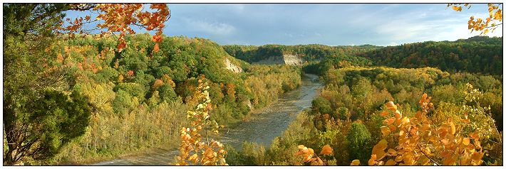
Martin's Point - Also know as "The Forks" and by some - Indian Head, Indian Face or Sculptured Ridge. It is located at the Confluence of the main branch and the south branch of Cattaraugus Creek. It gives the Valentine Flats area its southern border and it is what makes the area special. Its shear size up close is a wonder to behold with the eyes. The sounds of the two creek legs coming together echoes off Martin's point. It also marks the ending point of the central peninsula. Martin's Point is one of the gems of Zoar Valley.
MUA - see Zoar Valley Multiple Use Area
North Rim of Main Branch - Contains the longest hiking trail in Zoar Valley with many great views, like these:
Old Gravel Pit - no longer used gravel pit on the MUA Central Peninsula - returning to natural setting. The Gravel Pit access trail is located off Forty Road in the southern most portion of
the main Unit area and is accessible to the public for foot travel only.
Outlook Point or Overlook Point - see Lookout point
Plumb Brook Falls - This 45' ribbon cascade is off the MUA and on Private Property - No trespassing!
Plunge Cascade: On the North Rim of the main branch an 80' seasonal cascade down a tributary into Cattaraugus Creek. Accessible by raft and a short hike.
Primordial Cascade: On the South Rim of the main branch on a terrace across from Stonycreek falls.
Primordial Cascade Terrace: An old growth terrace across from Stonycreek falls. Contains an 117' American Elm, 132.8' White Ash, 130.9' Sycamore, 126.4' Black Cherry, 124.6' Sugar Maple, 99' Yellow Birch, 119' American Basswood, 129' Bitternut Hickory, 115.6' American Beech and 115.6' Cottonwood. A champion American Basswood tree here measures in at 128.7 is a species record height.
Purdy Access - Public MUA access area located at the end of Forty Road on the Central Peninsula. It is blocked with earthen barriers to
prevent vehicular access. Foot access by the public is allowed.
Pyramid Hill - Located prominently in the Valentine Flats section of Zoar Valley this very unique rock formation stands proudly above the Cattaraugus Creek. It is shaped like a three-sided pyramid with two sides forest-covered and the third side a 120 foot sheer cliff directly above the creek. The elevation of the top, which is only 15 feet wide, is 1012ft. The view from up top is spectacular albeit dangerous, the side facing the Cattaraugus Creek is straight down. From this top, there is an awesome panoramic view of the surrounding area. This unusual pyramid hill is the only known feature of its kind in all of North America.
Ross Cemetery - old private cemetery on MUA property.
Ross Pond - coming soon
Ross Pond Parking Area - MUA public access parking lot located on Vail Road in Erie County. DEC maintained trail from Ross Pond to Holcomb Pond starts here. Also the parking lot for the William P. White American Chestnut Plantation.
Ross Falls - This 120' high by 50' wide steep cascade (also know by some as Skinny Dip Falls or Bridal Veil Falls) is located on the Main Branch Cattaraugus Creek ridge next to Martin's Point.
Schoolmarms Falls - see Buttermilk Falls
Sculptured Ridge - see Martin's Point
Shower Falls - Off the MUA and on Private Property - No trespassing!
Skinny Dip Falls - see Ross Falls
Skinny Dip Terrace - An old growth area of the Zoar Valley MUA near Ross Falls. Contains many old growth trees including an 144' Sycamore along with several 100' plus Sugar Maples one measuring 124'.
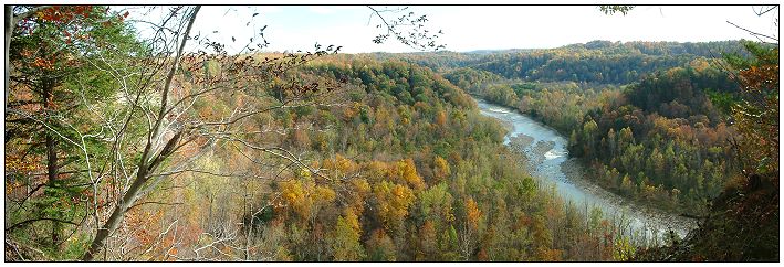
South Branch Cattaraugus Canyon: The canyon of the south branch. From Skinner Hollow Road to Hair Pin Canyon is mostly private property now.
South Branch Cattaraugus Creek - From Deer Lick Nature Sanctuary to the Confluence is public property of the Zoar Valley MUA. South of beginning of Deer Lick on the East Bank is private property. On the west bank south the MUA ends at the first turn of Hair Pin Canyon. Please observe the rights of the property owners and stay on the MUA land. This creek is in a beautiful Canyon and on the MUA contains three waterfalls - Little 4d, The Forty Road, Gossimer and Buff Cascade. Other points of interest are "the Point," the Forty Road parking area and rapids, and the Forty Road Canyon wall. There are terraces along the way that are dangerous to be on as the water rises QUICKLY in the area. In July of 2008 a group of hikers found out the hard way as they became trapped overnight. See examples of the high water level at the Forty Parking lot area.
South Branch Valentine Point -(This is my own name please contact me if you know the real historic name.)
South Rim of Main Branch
Stony Creek Falls: (also called Freefall Falls) On the North Canyon wall an 80' ribbon cascade which then falls directly into the Main Branch Cattaraugus Creek, viewable from creek.
Temple of the Giant Grape Vine - Bruce Kershner called this the world's largest (thickest) know wild grape vine. As described by him it is fourteen inches in diameter at its largest point - that is a huge forty-two inches in circumference. The combined length of this vine, its seven cables and countless strands at tree top height over 100 feet up is estimated to be more that a quarter-mile long. Estimated to be close to 400 years old this is yet one more are gem of Zoar Valley.
The Point - One of my favorite sites in Zoar Valley. My hikes to here go back to 1978. Hike upstream of the South Branch from the Confluence. Located on the left around the first bend on the middle peninsula.
The Trees of Zoar Valley - There are 46 known species of trees in the Zoar Valley MUA. The largest American Basswood tree known to date is in Zoar Valley. I have created a listing of the trees of Zoar Valley with links to information about each species with the Virginia Tech Tree ID site & Wikipedia. Also some interesting information & links to the Eastern Native Tree Society discussion group on Zoar Valley trees. Includes a list of the champion trees of Zoar.
Vail Road Gravel Pit Parking Area - MUA public access parking area located on Vail Road in Erie County.
Valentine Cave - coming soon
Valentine Chimney - coming soon
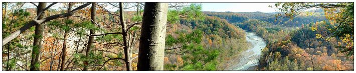
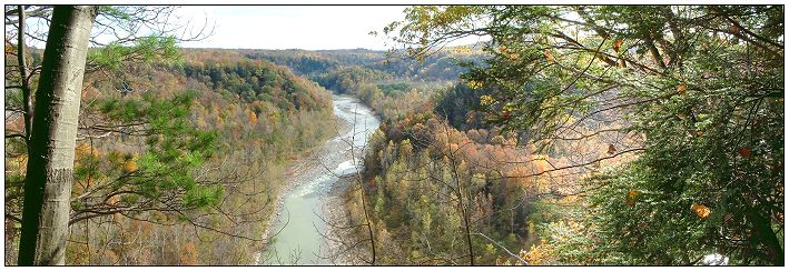
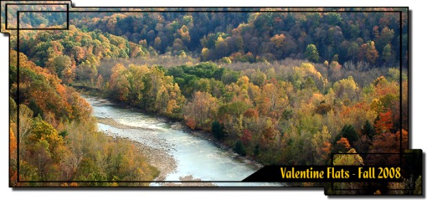
Valentine Flats
Valentine Flats' 160 acres is one of the most beautiful and awe inspiring sections of Zoar Valley. A mixture of creek beds, field, woods, one terrace with a walnut tree plantation speckled with sycamore tress, another terrace with old growth trees and a hidden waterfall (Bare Bunns Falls), and a very nice river beach, all surrounded by the cliffs of Zoar Valley Canyon. The cliffs are covered with ancient or primeval old growth forest. Raspberries and blackberries are abundant for the picking.
Valentine Flats starts at the Confluence of the south branch and main branch of the sometimes moody Cattaraugus Creek and ends downstream near Lookout Point. There are excellent views in all directions. The end by the Confluence, being towered by Martin's Point is special, you have to be there to understand why. The sounds of the creeks coming together along with the up close size of Martin's Point is inspiring.
Also to be found in Valentine Flats is a unique Pyramid shaped hill. The top of 182' Pyramid Hill offers a beautiful view upstream the main branch of Cattaraugus Creek with Hogsback Ridge viewable in the background. The area also boasts of two other upper rim lookout points with breath taking views - Martin's Point & Lookout Point. Lookout Point is a favorite of mine as it overlooks the entire area. Hiking along the North Rim of the Zoar Valley Canyon also sports some nice viewing points. The top tiers of Bare Bunns Falls is viewable from the North Rim. Grape Vine Alley and Valentine Chimney & Cave are other distinct landmarks of Valentine Flats. A marsh where hawks perch on dead branches looking for prey can be found in the south terrace. This is an excellent area for birding.
Valentine Flats Farm - Yonder ago the Valentine Flats area was a farm. Today all that is left is some building foundations.
Valentine Flats Parking Lot - MUA public access parking lot located at the end of Valentine Flats Road. This lot provides access to Outlook Point and unmarked foot
trails to Valentine Flats, as well as other areas at the top of the gorge.
Valentine Point - see Lookout Point
Wildlife Ponds - coming soon
William P. White American Chestnut Plantation - Part of the American Chestnut Foundation's effort to restore the formerly blighted American Chestnut to Eastern forests.
Zoar Valley Canyon of the Multi Use Area - Canyon from Hair Pin Canyon on the south branch to the Confluence, from just past Point Peter to the confluence of the joined branch and from the Confluence upstream on the main branch to just before the North Otto Road bridge.
Zoar Valley Canyon Proper - Canyon on the Main Branch Cattaraugus Creek west of Springville, NY downstream to east of Gowanda, NY.
Zoar Valley Multiple Use Area - This is a NYS DEC controlled 2,923 acre area located in Erie and Cattaraugus Counties and which adjoins the Cattaraugus Creek in an area featuring a canyon with steep walls. This Multiple Use Area was purchased under the 1960 Multiple Use Bond Act (1,498 acres), with additional land (1,425 acres) deeded by Herbert F. Darling. Along with the canyon or gorge associated with Cattaraugus Creek the area features natural forests, small areas of plantations and an experimental chestnut plantation. (source NYSDEC)
Other "Zoar Valley" WWW Links
- Art of Zoar Valley - The Springville Center for the Arts goal is to honor Zoar and the artists it has inspired over the years, educating people about this gem of Western New York.
- Citizens Campaign's Zoar Valley Page - Nice write up about Zoar Valley.
- Map of Zoar Valley - from Gowanda's Chamber of Commerce
- The Zoar Experience - The Zoar Experience offers a complete facility where you can plan your next event. It is the perfect place for family picnics, company get together's, weddings, birthdays, retirement parties, hunting, fishing, and hiking excursions.
Private Tours along with adventure packages can be designed to fit your needs and budget. Private adventure packages that can be arranged include kayaking, canoeing, fishing, hiking, bird watching, and snowmobiling and snowshoeing in the winter months.
- Tina's Zoar Valley Experience - Tina's return to Zoar Valley after 20 years away. Her trek to "the falls" with her family. Excellent pictures and fun write up. Thank's for sharing Tina.
- Zoar Valley Canoe & Rafting Company - For those who want to experience Western New York's hidden gem, white water rafting on the mighty Cattaraugus, through Zoar Valley, is the perfect springtime activity. You'll view rugged cliffs hundreds of feet high, waterfalls (both free falling and hidden by old growth stands of oak, hemlock and tulip), nesting bald eagles and you'll experience the finest white water west of the Adirondacks. The season runs from Mid-March through May and the ten mile trip takes approximately 2 to 4 hours to complete. For those who might want a milder version, a 6 mile run on the lower section of the river, is available.
- Zoar Valley Multiple Use Area - NYS DEC Page - Zoar Valley Multiple Use Area is a 2,297 acre area located in Erie and Cattaraugus Counties and which adjoins the Cattaraugus Creek in an area featuring a canyon with steep walls. This Multiple Use Area was purchased under the 1960 Multiple Use Bond Act, with additional land deeded by Herbert F. Darling. Along with the canyon or gorge associated with Cattaraugus Creek the area features natural forests, small areas of plantations and an experimental chestnut plantation.
- Zoar Valley Nature Society - The Zoar Valley Nature Society is a non-profit club with activities throughout the seasons in Zoar Valley.
- Zoar Valley - Chris's excellent Zoar Valley site, but it is outdated and no longer maintained
- Zoar Valley - Kurt Fox's birding information site
- Zoar Valley - John Stoneman's Zoar Valley site - many pictures and exploits of his various hikes in Zoar Valley
- Zoar Valley Paddling Club - now a non functioning group (October 2008)
- Zoar Valley Waterfalls - Scott A. Ensminger's MUA Zoar Valley water falls listing with directions.
Various "Zoar Valley" Articles From Other WWW Sites
- Amazed by tall trees -
Expert's spirits soar
discovering the giants of Zoar by John F. Bonfatti, News Staff Reporter Buffalo News, Sept. 24, 2001
- Helicopter rescues 9 from Zoar Valley Hikers, two dogs stranded after rains spur flash flood - Buffalo News, July 1, 2008
- Historic Tree Preservation Measure Now Law - Landis Arboretum Blog, September 30, 2008 - Initiative Named After Amherst Naturalist Bruce Kershner
- How to Enjoy Nature at Zoar Valley in Buffalo New York by Kathryn Radeff - Five Ways to Enjoy Zoar Valley
- Law honors area environmentalist Bruce Kershner - Buffalo News, September 14, 2008
- Legislation to Protect Zoar Valley Passed! - by Julie Broyles, June 7, 2007
- Nature's Cathedrals - Forests have roots in history - Team uncovers Erie County's oldest living treasures by Mike Vogel, News Staff Reporter Buffalo News, Sunday, August 3, 1997
- New Designation Protects Zoar Valley - NYLCV. July 11, 2007 - Governor Eliot Spitzer has signed a bill that designated the Zoar Valley as a unique area, granting it protection from logging, gas exploration and other development.
- New York State Assembly Bill A07542 - Bill to Protect Zoar Valley gorge area, dedicates the Zoar Valley Unique Area to the state nature and historical preserve.
- Not So Fast - by Peter Koch, July 13, 2006
- Old-Growth Forests in New York State Protected by Law - Old-growth forests in the state of New York are protected for the first time under a bill signed into law Friday by Governor David Paterson. The law applies only to state forests, not to forests on private lands or national forests in the state of New York. - Environment News Service (ENS) 2008.
- Spitzer signs bill granting Zoar Valley protection: 1,492-acre parcel will be forever wild - Buffalo News, July 11, 2007
- The Nature Conservancy to Protect 600 Acres in Zoar Valley - The Nature Conservancy, March 14, 2006
- Zoar Valley "Gallery of Giants" - by Steve Nix, July 11, 2007
- Zoar Valley -
is gorge-ous example
of tallest trees By Rick Miller, Staff Writer Olean Times Herald, September 24, 2001
- Zoar Valley Multiple Use Area UMP - Department of Environmental Conservation (DEC), February 1, 2007, "Final Unit Management Plan" the DEC's plan for Zoar Valley
- Zoar Valley Unique Area Dedicated to the State Preserve - Environment DEC, August 2007
Our Own Zoar Valley Discussion Group - Talk about this site & Zoar Valley
This page last updated
August 18, 2011
|